Road Closures
This is your one stop shop to make navigating Lincoln as easy as possible on race morning. Thanks for your support!
Road Closure Resources
These resources will help you prepare for navigating Lincoln on race morning.
Driving Detour Map
Download the Waze App to Avoid Road Impacts
The free Waze App can help you avoid road impacts and navigate Lincoln on race weekend. Plan ahead and know how to best travel east/west and north/south in Lincoln. Type Waze into your app store on your smartphone or visit Waze.com to get the app.
Timelines
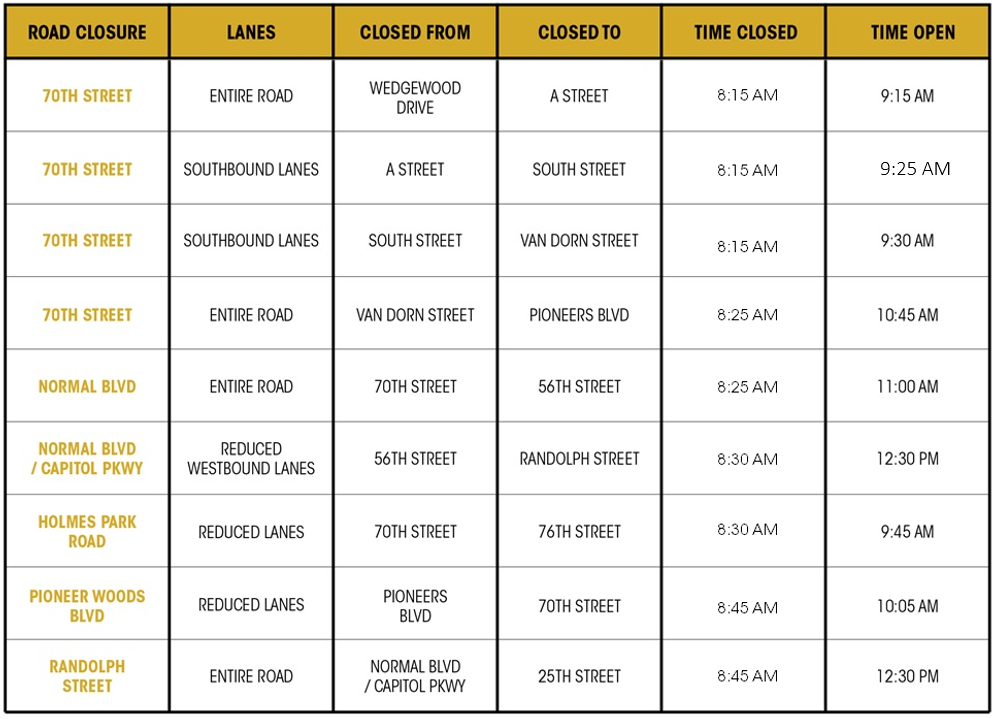
Roads will close to traffic approximately thirty minutes before the first participant and will re-open approximately thirty minutes after the last participant. Road closures and intersections will be controlled by Lincoln Police and Public works. Please follow their instructions when approaching streets on the course.

- Streets in Innovation Campus will be closed from 9:00 a.m. to 1:30 p.m.
- Some streets in the North Bottoms area will be partially closed and vehicles will be towed on the race course. In addition, no parking will be allowed from 14th to 6th streets from 9:00 a.m. to 1:30 p.m.
- All lanes of Canopy Street from “R” to “O” streets in the Haymarket will be closed from 5:00 a.m. to 3:30 p.m.
- The Arena Festival Lot and Haymarket Park Lot will be available for parking, but the remainder of the area will be closed from 9:00 a.m. to 2:00 p.m.
Suggested Driving Detour Routes
These are the best roads to use on race day to get around or cross the race route. Roads on the race route or crossing the race route will be closed, detoured, or heavily congested.
- East/West: Salt Creek Roadway, O Street, J Street, Pioneers Blvd
- North/South: 9th/10th Street, 16th/17th Street, Antelope Valley Pkwy, 84th Street
Get a Reminder!
Be in the know. Sign up for a reminder email and we’ll send you an update prior to race day.

